
VR Module · Civil · Engineering
Total Station Survey
Surveying & Geomatics
See it
Inside the module.
Learning objectives
By the end of this module, students will be able to:
Understand the working of a total station and its role in modern surveying
Set up the instrument with centring, levelling, focusing, and orientation
Measure horizontal angle, vertical angle, slope distance, and target readings
Calculate coordinates, reduced levels, height differences, and point positions using trigonometry
Perform backsight, foresight, point observation, and data recording
Recognise common survey errors - poor levelling, wrong target, incorrect backsight, and observation inaccuracy
Real survey workflows, in a virtual field.
A total station combines an electronic theodolite, electronic distance measurement, and on-board computation to measure angles, distances, elevations, and coordinates. It is central to construction layout, topographic survey, road alignment, building setting-out, and land measurement.
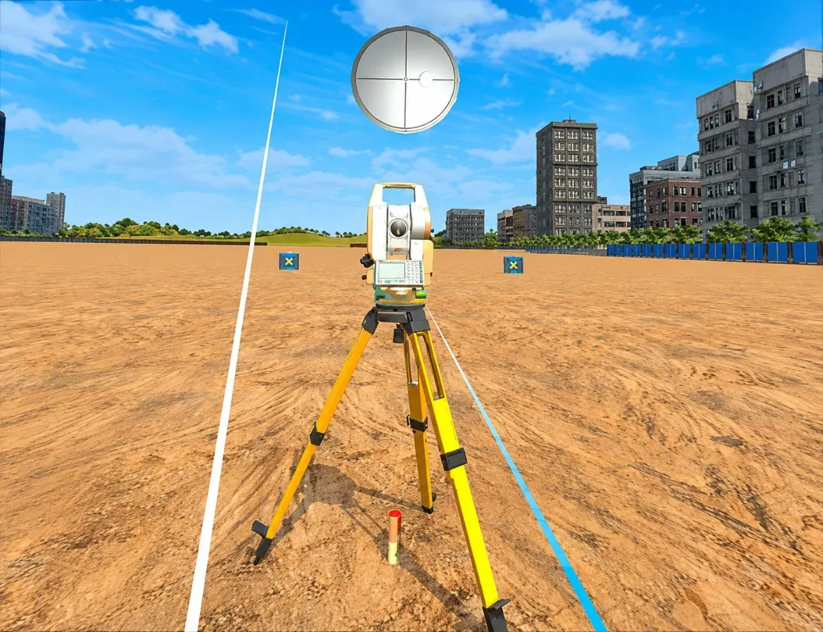
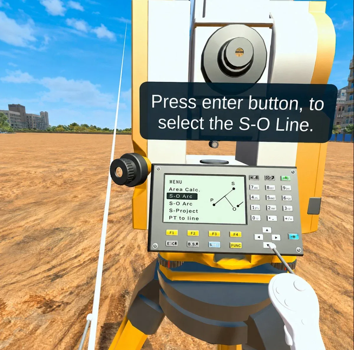
In this module, students work in a virtual survey field and operate the instrument step by step - setting it up, orienting it to a reference, sighting target points, and seeing how survey data is generated. A dynamic trigonometric calculation engine drives the results: values are computed from the learner's chosen points, instrument position, angles, and observation sequence, so different setups produce different readings.
Why a virtual surveying lab?
- Departments typically own a handful of total stations for cohorts of a hundred or more, so most students watch rather than operate.
- Field sessions depend on weather, daylight and a bookable open space.
- A virtual field can be re-run instantly, so setup and orientation get practised until they are automatic.
- Because results are computed rather than scripted, students can check the instrument against their own arithmetic.
The instrument and field
- Total station on its tripod
- Target prism and prism pole
- On-board keypad, menu, and display
- Backsight and foresight reference points
- A survey field with multiple target stations
Concepts it makes tangible
- Centring, levelling, focusing, and orientation
- Horizontal angle, vertical angle, and slope distance
- Reduced levels and height differences
- Coordinate calculation by trigonometry
- Backsight orientation and foresight observation
- Common survey errors and their effect on results
How the workflow runs
- Set up and orient the instrument to a reference
- Sight target points and take angle and distance readings
- A dynamic trigonometric engine computes results from your setup
- Different points and positions produce different, verifiable readings
How faculty use it
- Pre-lab activity so students arrive ready to survey
- Eases pressure on limited physical instruments
- Virtual survey lab for large cohorts
- Assessment of setup, observation, and coordinate calculation
That makes the link between field practice and theory concrete - horizontal and vertical angles, slope distances, height differences, and coordinates, alongside instrument and prism height, line of sight, backsight orientation, foresight observation, reduced levels, and coordinate transformation. It works well as a pre-lab activity, a virtual survey lab, or an assessment, easing pressure on limited physical instruments. The 7thi AI tutor and built-in assessment run throughout.
How the module works
Students work in a virtual survey field, and the instrument behaves like the real thing because the numbers are computed, not scripted. They centre the total station over a station, level it, and take a backsight to orient the instrument, then observe target prisms as foresights, recording horizontal and vertical angles and slope distances. A trigonometric engine derives reduced levels and coordinates from the student's own instrument position and observation sequence, so a different setup genuinely produces different results - and a student can check the instrument's output against their own hand calculation. Poor centring, a wrong instrument or prism height, or a badly chosen backsight propagate into the coordinates exactly as they would in the field.
What students take away
A student leaves able to set up and orient a total station without hesitation, perform backsight and foresight observations, and compute reduced levels and coordinates from their own field data. They understand how errors enter a survey and how they carry through to the final coordinates, which is the difference between someone who can operate the instrument and someone who can trust the answer. That fluency means scarce real instruments are spent on observation technique rather than on relearning setup every session.
In the classroom
Surveying courses use the module to solve a chronic bottleneck: too few instruments for too many students. Learners rehearse setup, levelling and orientation in VR until those steps are automatic, so that when they reach the small number of real total stations, that scarce time is spent on observation and fieldcraft rather than on relearning how to centre the instrument. It also serves as pre-lab preparation before a field survey camp, and as a way for architecture and construction-layout students to meet setting-out without a full surveying practical.
Interactive features and modes
Every operation of a real instrument is available: centring, levelling and focusing, backsight orientation, foresight observation, angle and distance measurement, and coordinate computation. Because a live trigonometric engine drives the results, a student's own setup determines the readings, and the effect of errors can be seen directly. The virtual field can be reset and re-run instantly, so the setup and orientation sequence can be rehearsed until it is automatic.
Why it matters
Surveying is a hands-on discipline learned through repetition, but a department typically owns a handful of total stations for a cohort of a hundred or more. Add weather, daylight and the need for a bookable open space, and most students get only a few supervised minutes on the instrument - far too little to make setup and orientation automatic. A virtual field can be re-run instantly and endlessly, and because it computes real results from the student's own setup, it builds genuine competence rather than rehearsing a fixed script.
The bigger picture
What makes the module more than a simulation is that it computes real results from the student's own decisions. Surveying is fundamentally about controlling and understanding error, and error is invisible in a scripted exercise where the answer is fixed. Here, a poorly chosen backsight or a mistyped instrument height propagates into the coordinates exactly as it would in the field, so students learn not just how to press the buttons but why careful setup matters and how mistakes cascade. That is the difference between operating an instrument and trusting its output - the distinction that defines a competent surveyor.
Devices, deployment and assessment
Deploying the module is straightforward. It runs on Meta Quest, ClassVR and Pico headsets, on WebXR-compatible browsers, and on the desktop without any headset at all, so a department can start with the hardware it already has and scale as it grows. Faculty can assign the whole module or specific scenes, set it as pre-lab preparation or post-lab revision, and track progress on a dashboard that records concepts mastered, time per scene and assessment scores, with export to the LMS via xAPI. The 7thi AI tutor answers student questions in context throughout, so learners are never left stuck and faculty are not fielding the same question forty times.
Who this module is for
- Civil engineering undergraduates from Year 1 studying surveying, geomatics or setting-out
- Diploma, polytechnic and architecture programmes covering construction layout
- Large cohorts where instrument time per student is limited
- Faculty running pre-lab preparation before a field survey camp
Syllabus alignment
Where this module fits.
ABET (United States)
Supports Student Outcome 1 through engineering knowledge in surveying, coordinate geometry, and field measurement, and Student Outcome 6 through experimentation, data collection, and interpretation.
NBA (India)
Maps to Course Outcomes in Surveying, Advanced Surveying, and Geomatics, supporting POs around engineering knowledge, problem analysis, investigation, and modern tool usage (notably PO4 and PO5).
University syllabi
Maps to survey lab experiments, unit topics, course outcomes, field practice, and assessment rubrics. Request a custom mapping.
AICTE / NEP 2020
Aligns with Civil Engineering, Surveying, Geomatics, and Construction Engineering outcomes, supporting experiential, competency-based, and digital tool-enabled learning.
Keep exploring
Related modules.
See Total Station Survey live in a demo.
Thirty minutes, the full module, your curriculum questions answered.
Are the survey readings calculated or pre-scripted?
Calculated. A trigonometric engine derives every result from the student's instrument position, target points, angles and observation order, so a different setup gives different readings that can be verified by hand.
Which survey operations can students perform?
Centring, levelling and focusing, backsight orientation to a reference, foresight observation, horizontal and vertical angle measurement, slope distance, reduced levels and coordinate computation.
Does it cover survey errors?
Yes. Students see how poor centring, an incorrect instrument or prism height, or a badly chosen backsight propagates into the computed coordinates - hard to demonstrate deliberately on a real instrument.
Can this reduce pressure on our physical instruments?
That is its most common use. Students arrive at the field session already able to set up and orient, so scarce real instruments are spent on observation practice rather than basic setup.
Is the assessment graded automatically?
Yes. Scores reach the faculty dashboard immediately, pass thresholds are adjustable, and results export to your LMS via xAPI.
Is this mapped to our curriculum?
It is mapped to ABET, NBA and equivalent frameworks, and we map it to your own surveying & geomatics syllabus before deployment. Request a custom mapping.
Can this be used in a flipped classroom?
Yes. Students complete Total Station Survey before the lecture, so class time goes on analysis and discussion rather than first exposure to the topic.
Does it integrate with our LMS?
Yes. Moodle, Canvas and Blackboard are supported, with SSO and xAPI export of session data and assessment results.
Are the survey readings calculated or pre-scripted?
Calculated. A trigonometric engine derives every result from the student's instrument position, target points, angles and observation order, so a different setup gives different readings that can be verified by hand.
Which survey operations can students perform?
Centring, levelling and focusing, backsight orientation to a reference, foresight observation, horizontal and vertical angle measurement, slope distance, reduced levels and coordinate computation.
Does it cover survey errors?
Yes. Students see how poor centring, an incorrect instrument or prism height, or a badly chosen backsight propagates into the computed coordinates - hard to demonstrate deliberately on a real instrument.
Can this reduce pressure on our physical instruments?
That is its most common use. Students arrive at the field session already able to set up and orient, so scarce real instruments are spent on observation practice rather than basic setup.
Is the assessment graded automatically?
Yes. Scores reach the faculty dashboard immediately, pass thresholds are adjustable, and results export to your LMS via xAPI.
Is this mapped to our curriculum?
It is mapped to ABET, NBA and equivalent frameworks, and we map it to your own surveying & geomatics syllabus before deployment. Request a custom mapping.
Can this be used in a flipped classroom?
Yes. Students complete Total Station Survey before the lecture, so class time goes on analysis and discussion rather than first exposure to the topic.
Does it integrate with our LMS?
Yes. Moodle, Canvas and Blackboard are supported, with SSO and xAPI export of session data and assessment results.